Art 5 – Rosebery

Artist Kaff-eine had earlier assisted with the Lascelles silo project. During this time she travelled to neighbouring towns, meeting the locals. Completed in late 2017,the left silo captures the grit, tenacity and character of the region’s young female farmers. On the right, the trust and connection between a contemporary horseman and his horse.

36A90A37-2258-4863-9831-9DA6C86BBEAF


Art 4 – Brim

Guido van Hellen’s Brim mural was the first silo artwork to appear in Victoria. After gaining widespread local and international attention, it inspired the Wimmera-Mallee Silo Art Trail.

The subjects in these paintings are generic rather than specific – intended to exemplify the resilience of the local farming community. They were painted over the period of 14 December 2015 to 4 January 2016.

72ED04C2-6C7A-4C43-82B7-807968A6A9CC

Art 3 – Sheep Hills

Sheep Hills has a group of four grain silos built in 1938. Melbourne artist Adnate used his work to tell the stories of the local indigenous people and their lands. Depicted are two local elders and two young children with the night sky representing elements of local dreaming. Completed in late 2016.

D8F6DDCE-7103-49E7-ABFD-00357656A8C3

93D572DB-1CC6-47B4-A879-9583E28D1ACB

Art 2 – Rupanyup

Rupanyup is the southern entry to the Silo Art Trail. The early 2017 work of Russian mural artist, Julia Volchkova, captures the sporting culture among the rural youth. Young Rupanyup residents in their sporting attire. A monochromatic work on conjoined steel grain silos.

69AC552D-F386-4D99-80EC-3EFF7F7A707F

The former railway station (minus tracks) is in the background.

Further down in the town, street artist Georgia Goodie, has paid homage to fire fighters on the old shire office building.

Surprising Art – 1

“Surprising” because I wasn’t planning a blog for this trip. An orienteering trip to SA.    But I’d decided to check out the Silo Art Trail in western Victoria and decided it’s worth recording the day I’ve had today.

It’s a part of Victoria I’ve hardly visited. An overnight stay in Stawell. The shopping centre is at the top of the hill with the old Powder Magazine a feature in one of the main streets. The usual chaotic street plan I associate with old gold mining towns.

Then headed north – past some old serious aqueducts – I wonder what agriculture they were supporting? And on to Rupanyup – where my friend Max was a primary school teacher in the early 1970s. So I had to drive past the school on the way to the silos. Then a bit of wander in the town. You could buy a serious tractor here!

Onwards north to Minyip, billed as the centre of Victoria’s Wheat Belt. It has a very handsome timber Lutheran church – the German influence all through here is evident in the road names. But no art on the silos here – OK check the map again. Got to go a bit further …

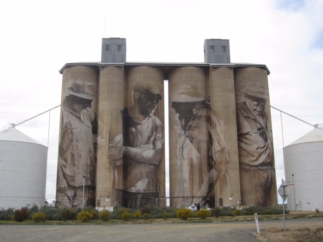
Sheep Hills is a bit off the main road. Silos, railway line, Mechanics Institute Hall, and a large (closed?) Hotel.

Hey, I’m loitering. I’ll never get to Renmark at this rate. The road goes through Warracknabeal – I remember one of our Dip Ed lecturers extolling the virtues of Warracknabeal but I’ll have to leave any exploration to another day.

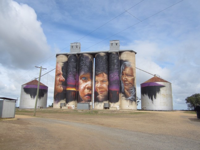
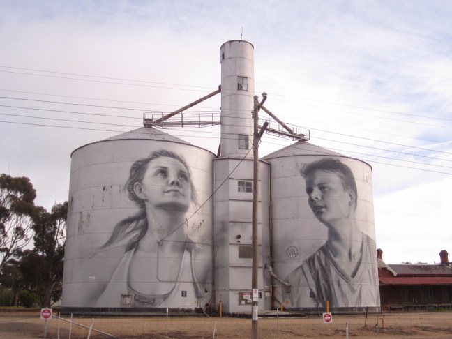
Now on the Henry Highway heading north. The first silo art in Victoria was at Brim, completed in early 2016. Since then the other five in this area have been completed by different artists who all spent time in the local community before selecting models for their artwork. The trail is being well publicised and has good signage at each site and pamphlets available at Rupanyup.

North through Beulah ( the barley centre of Victoria) to Rosebery – like many locations in the Wimmera-Mallee, named locations have not much more than silos and a railway siding.

The country is looking pretty good. Dark green of wheat on one side of the road, yellow canola on the other, alternating. But what is that crop? Sort of looks like legumes? And right on cue is the informative sign at Rosebery – the main crops in the southern Mallee: wheat, barley, canola, chick peas, field peas, lentils, oats and vetch. OK, so what I saw was probably lentils.

I’m going to need fuel – perhaps Hopetoun. That will be bigger … but the apparent petrol station looks derelict and despite the 24 hour sign, I drove past.

Next to Lascelles at the junction of the Henry and Sunraysia Highways.

Finally got fuel in Speed – an automatic 24 hour payment system, but this place looked more loved!

Then west to the final silos on this trail at Patchewollock. Now definitely in the Mallee.

But I’ve still got to get to Renmark – via Walpeup (doubt that it broke any Met Bureau records today)  and Murrayville, almost on the SA border. Years ago when the high school there was trying to attract teachers, they advertised as “surrounded by hundreds of square miles of rolling desert”. But despite the public holiday (nothing open all day to now) the cafe is open and with a very extensive menu – next time you’re in Murrayville!

Over the border to Pinaroo and then north to Renmark.

Cold again!

Well I’m home safely. 32 deg yesterday, 13 today.  And a fair bit of winter still to come (I had my winter holiday earlier than usual this year). Sigh!

Yesterday I was unexpectedly able to catch up with my young friend Cat, who is a doctor in Arnhem Land communities. How lucky are they to have her expertise!  A great way to finish the trip.

So this blog will again go into remission until next time.  Thanks for reading.

Darwin

I haven’t actually had the time or energy to fully explore the delights of Darwin. So just a few notes here. The location is interesting with an escarpment along the southern side of the central city and on the western promontories. Otherwise the whole area is quite flat. I didn’t get a real photo, but this old photo shows the row of buildings across the top of the scarp – that water is where the current waterfront park and swimming are.

342C3B6E-B83B-416E-A801-242D4268BCF6

The central area reminds me a bit of Townsville – offices and tourist stuff. Doesn’t seem to have many shops/services catering for locals. The main shopping centres seem to be out in the suburbs (Casuarina, and further out at Palmerston).

I must admit to getting directionally confused – not helped by my main central-area map being oriented to fit the A3 page, with north-east at the top of the page. From the highways coming from the south, you then drive south into town! The sun always seems to be in the wrong place.

The two defining events are the 19 February 1942 first Japanese bombing which destroyed most of the town at that time, and when everything had been rebuilt and starting to ‘motor’, Cyclone Tracy 24-25 December 1974 again destroyed the town. (Ruth’s parents were here then!) All the historical signage describes how this place was rebuilt (or not).

Christ Church Anglican Cathedral – just the stone porch remained:

24AD16BA-C752-4068-9236-F1D09E0BA1B9

There are apparently just 4 prewar houses in a group remaining – built on the escarpment at Myilly Point for executives in 1938-39. They include walls made of louvres so the walls could be completely opened to the breezes, and minimal internal walls. (I’m hoping to get there tomorrow to see inside.) A couple have been restored after some damage in 1942 and 1974.

95B20936-3DDF-451B-BF52-7F29913FEB4A

By the time I got to the Military Museum and Defence if Darwin exhibits, I was pretty much ‘over it’.

Interesting waterfront area with parks, restaurants, swimming and wave pool. The big play equipment seems to be privately owned.

1C05256A-3894-47A6-AD1F-7139922F9743

We’d seen TV reports early in the year about damage from the big cyclone – the buildings are now all built to withstand cyclones, but a lot of tree damage. Still a few uprooted trees in evidence. And a notice yesterday that the green waste tip is now closed. But not all the trees are yet cleared!


Independent travel

Today in my hire car, I had my only ‘serious’ independent travel of this trip. Headed south 110 km to Adelaide River which hosted over 30,000 troops during WW2. Several signs along the highway pointing to old airfields – most at right angles to the highway, but a couple seemed to run alongside the road.

i hadn’t expected to find a Commonwealth War Graves Commission cemetery in Australia. Appeox 400 service personnel and 34 civilians buried here, dating from the first bombing of Darwin on 19/2/1942 through to 1945.

6D086238-95CE-42B3-A8C3-75BF8BE16347

So then I retraced my route to go into Litchfield National Park, aiming for swimming at a couple of waterfalls. It was further off the highway than I’d anticipated.

First stop Wangi Falls. Big pool. Lovely picnic area. Not as cold as at Jim Jim and I easily made it across to the falls

6717E7D1-7629-4567-8785-68E39B7E5B79

Then back to Florence Falls – this time parking is at the top of the escarpment so 135 steps down to creek and pool level. A smaller pool but still well worth the effort.

1BEB0BB2-E660-478F-ADA8-0A936D9F76C6

And I got back with only 460km on the car clock. Paying for excess km over 500km so won’t do much driving on the way to the airport tomorrow!


More Kakadu

Driving through on the main road gets a bit monotonous. Vegetation not particularly attractive eucalyptus, palm, occasional red-flowering turkey bush, and at least half of it recently burnt. (The annual early dry-season burning cycle to cut back the fuel load against more destructive bushfires with lightning strikes later in the year. Also helps regeneration of species that rely on fire and encourages new growth.) a bit further south some more attractive open savannah country with tall termite mounds. But you’ve got to know the good places away from the road (some can be accessed by 2wd) and it helps to have a good guide who can explain the rock art etc.

Ubirr in the NE of the tourist area was well worth the visit – good rock art and a climb to a high point with 360deg views over the wetlands that we hadn’t much seen earlier.

Hunting figure: game spear in left hand, fishing spear in right hand, various dilly-bags

4D4705F7-C6F5-4D91-9308-9C9A1249A671

1b87b919-25f0-4085-bd81-13985e6bc3c5.jpeg
Long necked turtle

The white boss-man:

58A31FF7-3849-439D-A055-952456EAB096

Over 4000 years ago there were Thylacine (Tasmanian tigers) here.

B607E3E4-DB2D-463D-935A-DE2F4D26CF3C

Near here, minerals leaching from the rocks caused swollen joints and sickness. Stay away from here:

7AB9FB8D-D1EF-46D0-ACFE-523D0231AB3A

E229CDC6-FFEC-47F3-B4E8-9B5BE600320E

Then a cruise on the East Alligator River (which is still tidal here, over 50km from the coast) and which is the border from near here and out to the coast between the National Park and Arnhem Land. Need a permit to go over there. Our guide is from Gunbalanya 13 km over the ‘border’ where my friend Cat works as a doctor. I asked him to say hello to her. I wonder if he will? Lots more crocodiles and the only road crossing into Arnhem Land.

34E7B104-5D07-418C-A1A0-46B389D389E1

After lunch a quick drive out to peer though the fence at the Ranger uranium mine. Mining has ceased but they are still processing the huge stockpile. Still around 200 workers apparently. Jabiru is a company town. Got to work at the mine or in a service industry to live here or join the golf club etc.

Eventually we headed back to Darwin. Around 3 hours from Jabiru.

Another day, Another adventure.

On Saturday I joined an AATKings bus trip to Kakadu. 6:30am start. 27 on the 50-seater coach. But a curious mix – some were on a day trip, 7 of us on a 3-day, don’t know about the others. We saw an indigenous cultural centre (though I would like to have stayed longer to listen to the guy talking about stuff), a cruise on the creek near Cooinda. Lots of big estuarine crocodiles (not ‘saltwater’ – they can do either fresh or salt water) – keep your hands inside the boat! And some interesting rock art.

He’s at least 4m long.

570735FD-199C-4657-AC63-204A2EBAB6FD

But when we got to the hotel there was some confusion. “Pick up tomorrow at 8am”. But my itinerary says 6:45! One of the others phoned the office: definitely 8:00. I phoned: I’m definitely 6:45. So at least two different itineraries among the 3-day people. The logistics!

Turns out I was the only one from our original 27 doing Jim Jim Falls today. 16 people gathered from far and wide. Our guide a nice young man with a pressured time scale for the day. “Now this is a very difficult walk and we’ve got to keep a good pace. There is a lot of rock scrambling. If anyone has bad knees or ankles, i suggest you join Bob over there on his itinerary.” Repeated that a couple of times. “If anyone can’t keep up, I’ll just leave you to sit on a rock until we get back.”  I finally said, well if I’ve got to, I’ll sit on a rock but I want to give it a try. To make his point about what might be required, he did a ‘parcour’ leap over the adjacent picnic table! I was a bit anxious. So we started off, me with my stick. “You might want to leave the stick behind – that will make it difficult for you when you need two hands for the rock scrambling.” Me: I’ll see how I go.

So we headed off up the track to Jim Jim Falls (c.1 km, ETA 1 hour). I was soon left almost at the back but by the time we’d reached his ‘sit rock’, he’d decided I could cope and he slowed down a bit. So we all got there in 45 minutes. Not a lot of water coming over, but we had to have a swim because we could. Too far in the cold water to risk trying to reach the falls.

It’s the burning season. A bit hazy today

48097E13-9C7F-41E3-A47F-9FF6F4216F5F

The original itinerary had us going to Twin Falls but the road in there is still closed. So a long drive further south (though a shorter walk in) to Maguk Falls. Smaller but more water and very pretty. I left my togs in the bus (decided I didn’t want to get into Wet togs) and regretted it. A nicer pool I reckon.

A5E1A04D-7DD9-495B-BA3F-2AA29136B30B

AC0407C1-BAC8-49CB-9DD5-35058CAD2CCE

So more driving than we’d have liked – but John would have approved of the way our driver/guide dealt with the corrugations on the 4wd tracks!

i was probably the oldest in the group(though a couple of the men probably not far behind). A bit slower than most, but I got there ok and only needed a ‘hand’ at one tricky creek crossing in the afternoon.

A good day.