Nearly done.

Someone asked me last night if I was ready to go home. I replied that I hadn’t really thought about that, so perhaps I wasn’t.

However I came to San Francisco late on Thursday night. And going into the city yesterday, I kept seeing photogenic views or objects and thinking “I took a photo of that when I was here 10 years ago; don’t need to do that again.”  Caught up with Chorus friends yesterday. They are full of what they’ve been doing – hop on hop off bus, off to Lombard Street, Haight Ashbury. I don’t feel the need to do all that again. Perhaps a combination of familiarity, or maybe it’s just travel-weariness. Maybe I am ready to go home – but just in denial because I don’t want another long flight (5.5 long hours from Montreal on Thursday night).

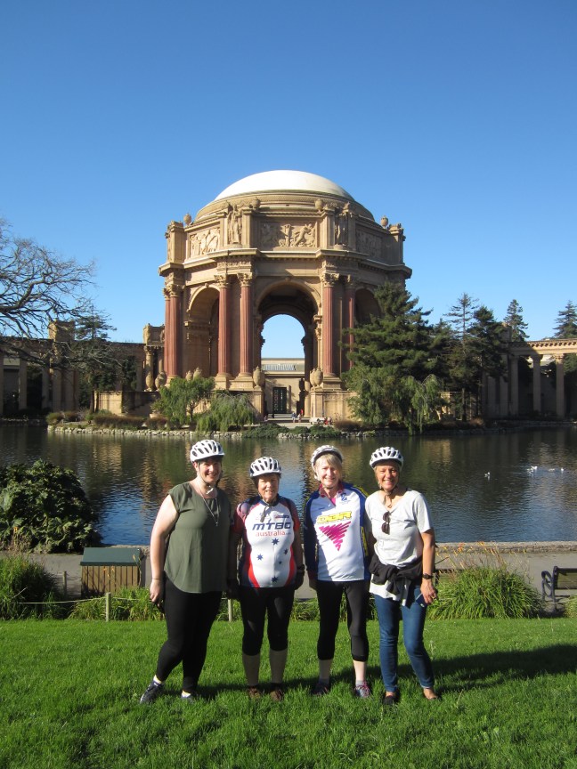
but first four of us (with 22 others in one of the biggest groups of the week) took a guided bike tour over the Golden Gate Bridge yesterday morning. Lovely clear sunny day. Great views. Excellent. Here we are at the Palace of Arts from the 1915 World Fair (subsequently rebuilt/restored).

img_2616

Ferry trip rip back from Sausalito then seven of us went out to dinner. The others are all heading home today. There will be just two others from our Las Vegas group on my plane tomorrow night. (They were touristing further afield yeasterday and not back in time for dinner.)

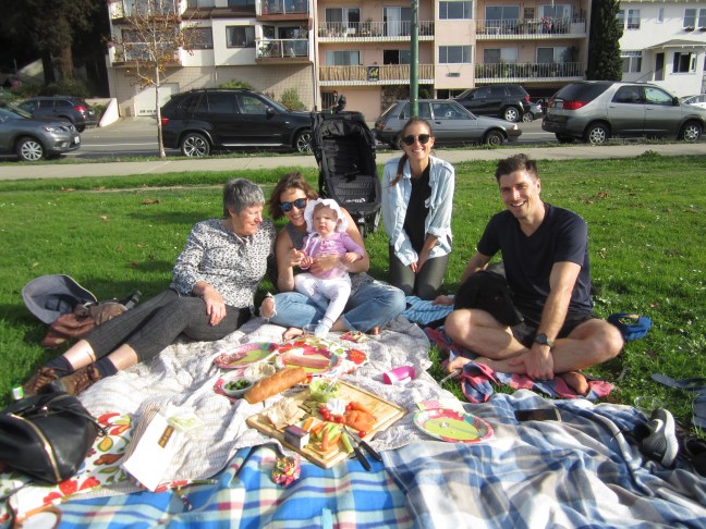
Today I caught up with my youngest nephew, wife and baby. He is over here working on a business venture that he started developing in Sydney a few years back. His two sisters have also been visiting so it was quite a family reunion. A picnic lunch by the lake in Oakland near where they are living. Great afternoon.

img_2640

Daylight saving finishes tonight. Too hard to figure out what that will do to the time difference. 18 hours has been easy to calculate.

A plan to check out the Golden Gate Park and other parks tomorrow before my late night departure.

Canadian Postscript

It’s raining again in Montreal today. After an hours walk I retreated to the underground city and finally back to retrieve my bags and fill in the last hour before the airport bus. A few final glimpses.

Lots of public telephones though I haven’t seen any being used. And occasional colourful post boxes. And a lot of road construction going on  perhaps a race before the snow comes?

Bicycles are out despite the weather or terrain. And I haven’t completely missed the fall colours.

Winter is is nearly here.

img_2553

Views from heights. Looking down onto Vieux basse Quebec, and From the top of the Montmorency Falls to the bridge to the isle of Orleans.

Dogs. Not many in these urban environments but I got a brief fright yesterday in the woods  on Mt Royal. A large brown dog and at first I didn’t see the owner or leash. Is it a bear?

The underground city: all the serious shops are underground and many of the metro stations have long underground tunnels interlinking with neighbouring blocks and offices as well. And metro stations – both platforms for the line are together and often open to the concourse: a much more open environment than Melbourne’s tunnels. (And in Boston, the green line trains are more like trams and it’s possible just to walk across the line to the next platform. )

A Walk in the Woods

Back in Montreal.  I didn’t think I’d ever be hot outside in Canada! Thought I’d dressed fairly lightly yesterday afternoon but the jacket was soon discarded and as the afternoon wore on I considered taking off another layer – but that would have exposed skin and that seemed a bit rash! (And when later I walked out to find dinner, I didn’t even take a woolly hat! A rare warm day at 13-14 deg C. )

So the plan for the forecast fine day was Parc du Mont Royal, on the prominent hill (they prefer “mountain”) on the western edge of the city centre. 233m above sea level. A very steep escarpment towards the city, only slightly less steep on the other sides. Wooded on the E side and partly on top, open park areas on top, and cemeteries on the far side.   Advice was to take the metro and then the bus. Got off at the first high stop and walked from there. Very little sensible signage. One bitumen circuit pedestrian/cycle road. And a Criss-cross of bush tracks that barely showed on my town map. When eventually I got a Proper map, they still weren’t all that clear. Just a few ski trail signs but those numbers weren’t on my ‘summer’ map. A fair bit of ‘go this way and hope for the best’ – just don’t end up too low down on the town side.

img_2580
Will this take me where I want to go?

The centrally-located chalet has a huge ballroom space and large terrace overlooking the city. All gearing up for the ski season.  Further on the lake is waiting for the figure skaters. And the underpasses have the ski signage in place too. All know that this warm day is just a blip.

A very pleasant afternoon.

Art in Quebec


No way let me hasten to assure you that I did not frequent the art galleries. In fact I didn’t spend much time indoors at all! But found some interesting art nevertheless.

In a short cul-de-sac near my hotel, a sculpture: River Man (sorry, I didn’t write the name in French)

img_2515

And away from the old town, down on the lower side of the hill, the freeway rises with an exit to the upper level, leaving a forest of pylons which have become a feature of street art. 

And very little tagging graffiti.

Mainly history in Quebec

The main feature, to my mind, is the geography. And that depends on the geology. And I haven’t been able to find a sensible and simple explanation. There appears to be a raised plateau a couple of km across and many km long with the St Laurence River along one side and lower ground on the inland side.  And quite a steep slope, even on the inland side. It seems to be metamorphic rock – seems to be limestone and slate – and clearly quite hard to have resisted erosion and kept its shape. I’m conjecturing … but this geography was important in the history.

The first settlement in 1608 was down beside the river but soon the heights became important in the defence of their positions, and in lulling the French into a false sense of security when the British finally prevailed. Montcalm is reported to say “can they fly?”

In the late 1970s the City Fathers decided that tourism was the route to the revitalisation of Quebec and they’ve done a good job.

At the foot of the cliff, the early town:

The next day I went found some woods to walk in, albeit within sight and sound of the container port, just down from Battlefields National Park and the Plains of Abraham. Up there, a school group was preparing to reenact the British (General Wolfe) defeat of the French (Montcalm) in 1759. They practised marching and advancing to the beat of their drums. I didn’t wait to see the inevitable conclusion, but later discovered that as the British and French forces faced each other, they didn’t open fire until they were only 35m apart!

So then I took a town bus to Montmorency Falls. A lot of water coming over there! 83m high. The bus delivered me to the top. Couldn’t get to the bottom – the serious-looking steps were closed, as was the cable car on the opposite side. Back in June, General Wolfe was defeated on the heights near here but he got his revenge in September

Arrived in Quebec

Quebec has definite tourist possibilities! Except that the winter tourist timetable starts on 1 November: that’s Tuesday. So decisions on what to do this afternoon and tomorrow …  at least the sun is peeking through.  Turns out they do have sun in Canada.

This afternoon was the Citadel – an army base and Governor General’s second residence at the highest point of Quebec. Right on the edge of the cliff overlooking the river so that gives good protection from invasion.  Then fortified walls around the rest. Great views.

I then walked a bit of the wall around the old town – North America’s only walled town.

Then a bit of a wander to get my bearings. Noted that the yellow snow poles are already out to keep pedestrians on the paths once the snow comes.

And found the cold & flu capsules at the bottom of my travelling apothecary. Reckon I’ll need them against the cough and sneezes by tomorrow. But I’m keeping warm and all is good.

Montreal

Thursday moving day. Rode the Greyhound to get here. A longish day. I’d chosen to go via Albany NY rather than direct, to give a midday leg stretch. A nearly empty bus to Albany, but then a full bus with a crowd that had come up from New York. Started to snow lightly in Albany and in a while there was quite a lot of snow out there. I guess we’d got a bit higher although the road appears to follow a valley north. Lake Placid up there somewhere on the left. Then as quickly as it had come, there was no more. Just raining as we arrived in Montreal in the gloom. 5 deg C and raining, with rain forecast for the next few days. Hmm.

So my clothes were adequate. Main problem is moving from outside to in. First stop on Friday was the Info Centre. So hot I had to do a serious strip off before I could sensibly talk to the guy. Off. on. Off. on. How do they cope?? I briefly considered the hop on- hop off bus but decided I’d be better walking. Headed to the old town. The overall impression is “not all that old”. Substantial buildings look a bit like 1890s Melbourne.  I needed to find more history.

The Pointe à Callière Museum of Archaeology and History. Built on top of an archaeology dig. The immediate previous building was a substantial insurance office building with tower that had to be demolished when the tower’s foundations started to collapse. A site that was an original point of land between the St Lawrence and a smaller stream. After several lots of rebuilding on the point – from dignatory’s house to inn and then the stream which had became an open sewer as the town expanded on the slope above, was made a tunnel sewer and built over.

The Dig has extended towards the slope. And in the basement of the museum are the foundations of the insurance building, and the excavated town wall and cobbled streets.  And plumbing evidence. Displays of excavated pottery etc. and good signage explaining the development of the old town on the low hill above the river.

1642 was fur traders and missionaries. 1701 a treaty with 38 Indian nations gave the French effective control out to the Great Lakes and all the way down the Mississippi to Louisiana. 1721 a large fire destroyed most of the town. 1763 the Treaty of Paris gives the British control.  1774 French language again permitted to encourage these colonists to support Britain in the American Revolutionary War. Montreal flourished as a port and trading centre before a slump late in the 19th century.

A resurgence since WW2 or so. And a resurgence in French language and culture since 1920s.

When I’m away I like to check out the bushier areas. In the rain with my newly purchased umbrella, I went to the islands in the St Lawrence river just across from the port. Summer playground. Not much happening today. On St Helene Island, Some  nice treed areas. A fairly wild gully and rocky hillside. Hosted a British garrison 1820-1865 with remaining buildings. The neighbouring island, Notre Dame, is linked by bridges and has a motor racing circuit, Olympic rowing course and Casino – and not much more …  this island, perhaps both? Hosted Expo in 1967. Still a couple of pavilions remaining. And bike paths. I think that the St Lawrence ship canal runs along the far side of this island (other sections of the river are quite shallow through here) but despite a lot of walking I couldn’t verify that! And a failed effort to take a Bixi bike to,explore further.

A bit footsore and knee sore tonight!  Now to pack to move to Quebec tomorrow.

From top left, clockwise: Dorchester Square with Boer War memorial, old houses near the Pointe, on St Helene Island,view to the city from the island

Photos on the next post, hopefully.

More Boston photos

The first, the sign in Quincy Hall!

the second, one of the quotes from the JFK museum

Is that all the photos I promised?  I’ve had such problems with these – WordPress is not as friendly with photos as the previous software I was using !

I’m moving on …